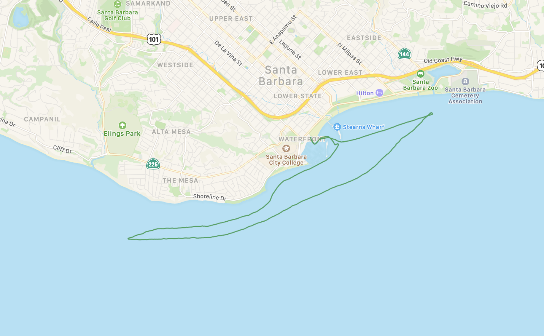
Santa Barbara Coat Hanger
Share this run
Start & Finish
Start and end at the Santa Barbara harbor boat ramp by the paddling dock or on the beach.
34.408435, -119.691980
Except on busy week-ends you should be able to find parking in the boat ramp area, if not, you have a little more boat carrying to do.
Parking will cost around $6 for 3 hours (2021).
Run Length
17 km
Shuttle Length
17 km
Weather & more
For a good 4mi+ downwind run you need afternoon wind out of the south-west, west, or north-west.
Wind conditions can be estimated from the conditions at the end of the pier.
https://mesowest.utah.edu/cgi-bin/droman/meso_base_dyn.cgi?stn=NTBC1
https://mesowest.utah.edu/cgi-bin/droman/meso_base_dyn.cgi?stn=KSBA
Use the sites above for accurate forecasts.
The time of day is almost always in the afternoon due to thermals, which the normal forecast models (GFS, ECMWF, NAM) don't really show.
As you paddle out of the harbor stay right and paddle SW along the breakwater to enjoy a stability exercise or further out of you'd rather not.
Aim for the palms atop leadbetter point to get a bit of wind shelter and turn south as late as possible to avoid a large kelp bed.
Curve around the point as breaking waves permit and peer into the distance SW to locate the 3 yacht club buoys showing as little sticks on the horizon.
You're aiming for the furthest one (marked "A"), which is about a mile straight out from a white lighthouse sitting atop the cliffs of the mesa.
In moderate wind, head straight to that buoy, in strong wind stay closer to shore but beware of two large kelp beds you will pass.
On good days it's worth going further up into the wind and if you're close to shore, once you pass the mesa you should encounter waves allowing you to surf back out away from shore into the main wind and waves.
The downwind section starts as soon as you turn around.
Make a wide curve around leadbetter point depending on conditions and safety.
As you come around the point and see the harbor keep an eye out for the tall red navigation marker, or the Montecito Country Club (big white building up on the hills straight ahead).
That's where you are aiming. Once past the navigation marker when the waves run out or you hit the beach head back upwind to the harbor.
Total distance can be anywhere from 6.5mi if you "abort" on the way back at the navigation marker to 12mi+ if you maximize the downwind leg.
The downwind portion is 3.5-5mi long and the character changes quite a bit section to section due to coming around the point. Surprisingly, the last bit after the navigation marker can be a lot of fun because the waves are often nicely organized there.
The course name comes from the shape of the GPS track, which looks like a crappy wire coat hanger bent a bit out of shape.
Contributor
Thorsten von Eicken